Chris Wilson is offering a car share from Keswick to Crinkle Crags. The event starts at Three Shire Stone, Wrynose Pass summit. NY277027. Starting 10:00
If you would like more details or save a seat please contact us.


Enable to display posts in the homepage news feed
Chris Wilson is offering a car share from Keswick to Crinkle Crags. The event starts at Three Shire Stone, Wrynose Pass summit. NY277027. Starting 10:00
If you would like more details or save a seat please contact us.
David led 20 of us past the remains of the Hodbarrow Mine on a dry breezy day. Its main ore body, the largest in Cumbria, measured 600m x 600m x 30m and was close to sea level. At first we walked along the flexible Outer Barrier with its watertight puddled clay core skirting the smaller Moorbanks ore body. The rigid Inner Barrier had failed so the main orebody area had flooded when the mine was abandoned. Our lunch stop was in the Red Hills Quarry in the eponymous highly dolomitised limestone. The beach at Haverigg Point had a very varied mixture of interesting erratics and highly coloured furnace slag and clinker. Our final stop was a fossiliferous locality in the Red Hill Limestone exposed in the faulted anticline. It had thumb length crinoid columnals and tennis ball cross sections of gastropods.
Mervyn Dodd
As the trip to Crinkle Crags is much more physically demanding than usual, those thinking about coming along should be given a good idea of what is planned. Your leader Clive Boulter has created a preview presentation of what can be expected.
The Crinkle Crags event will have a fine weather and poor weather alternative. Below you can find the two presentations.
[jupdf-viewer file=https://www.cumberland-geol-soc.org.uk/wp-content/uploads/2016/08/2016_September_Crinkle_Crags_Excursion.pdf width=800px height=600px]
[jupdf-viewer file=https://www.cumberland-geol-soc.org.uk/wp-content/uploads/2016/08/2016_September_Crinkle_Crags_Low_Altitude_Alternative.pdf width=800px height=600px]
11 members and friends of the CGS travelled by ferry to stay at Melrose House, Douglas where we were given an introductory evening talk on the general geology of the island in its Plate Tectonic context by our leader for the week, Dr. Steve Crowley of Liverpool University and each issued with a detailed booklet of the locations to be visited in the next three days. isle of man
Tuesday 12 July The main theme of the day was the events of the Lower Palaeozoic including the Lower Ordovician Manx Group submarine fan deposits exposed in locations around the south coast, late Caledonian deformation and regional low-grade metamorphism, Foxdale Granite magmatism and contact metamorphism and base metal mineralization.
Wednesday 13 July This day dealt with basic magmatism, the contact zone between Manx Group and mid-Silurian Dalby Group turbidite meta-sediments, mid-Silurian sedimentology, late Caledonian deformation and regional low-grade metamorphism, and Lower Devonian fluvial sediments of the Pele Group.
Thursday 14 July Our main focus on this final day was the sedimentology and volcanology of the Lower Carboniferous carbonate-dominated succession exposed around the south coast in the Castletown area.
Apart from two short but intense showers on Wedneday afternoon we enjoyed good weather and visibility. We are indebted to Fiona Harwood for driving us around in the hired mini-bus, to Susan Beale for organising the visit and especially to Steve Crowley who constantly kept us informed and stimulated throughout a concentrated three-day period.
JR
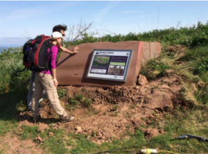
On 11 July 2016 Mervyn Dodd unveiled two interpretation boards at Birkhams Quarry on St Bees Head. Mervyn, a founder member of Cumbria GeoConservation (CGC, then known as Cumbria RIGS) designated Birkhams Quarry as a RIGS site in 1997 (LGS 4/030) for its ‘fresh cross sections through fluvial sandstones which show sedimentary structures clearly’.
As befits a geologist, Mervyn first set the scene by walking the group to the north to give a view of the Barrowmouth unconformity. A change from purple to a buff colour on the wave cut platform far below shows the eroded surface of the Upper Carboniferous Whitehaven Sandstone, above which lies the Permian Brockram and Magnesian Limestone and shales and the overlying Triassic St Bees Sandstone which forms the present headland and cliffs.
The boards are the result of detailed collaboration, between CGC, Cumbria County Council planners, the quarry company Marshall Stancliffe and their agents Stephenson Halliday of Kendal who prepared the many documents for the planning application. Planning approval has now been given to extend the quarry back into the headland. The geological interpretation, text and block diagram, for the geology board was the work of Elizabeth Pickett and was designed by graphic designer Marcus Byron in line with the design brief of the National Trust’s Colourful Coast. Most of these people attended the formal unveiling at the quarry, as cloths were whisked off, champagne glasses were raised and rock cakes (what else?) were consumed, to the general interest of the many Coast to Coast walkers that morning.
The geology board shows an interpretation of the area 250 million years ago when the sandstone was laid down, and the quarry board explains the quarrying processes and products. Each board is placed on a cut face of a large sandstone block, chosen by CGC members and taken to Locharbriggs quarry near Dumfries to be cut and shaped. The blocks themselves show excellent examples of current bedding, ripple marks, mud clasts, reduced layers and small channels. A visit is strongly recommended.
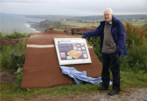
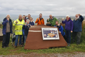
In photograph: Mervyn Dodd (founder member of Cumbria RIGS, now Cumbria GeoConservation); Steve Boam (Quarry Manager, Birkham’s Quarry), Marcus Byron (Designer), Sylvia Woodhead (Geological Coordinator, Cumbria GeoConservation), David Forsyth (Landscape Architect, Stephenson Halliday), Elizabeth Pickett (Geological illustrator), Peter Woodhead (Chair, Conservation Group, Cumbria Wildlife Trust), Clive Boulter (Cumbria GeoConservation), Julie Harrald (Director, Geology Trusts and member of English Geodiversity Forum), Audrey Brown (Chair, Cumbria GeoConservation) and Chris Brown (Cumbria GeoConservation).
Photographer – Chris Thompson (Treasurer, Cumbria GeoConservation).
Wednesday 17th August. Storm damage on the River Greta. Leader Alan Wise.
Meet 6.30pm at Booths car park, Keswick. CA12 5NZ (GR NY 26326) Wellingtons recommended.